The Green Patch Is Not Always a Meadow
Learn how to read a green patch without mistaking it for a meadow, using its plants, boundaries, access and management clues to judge its likely role.
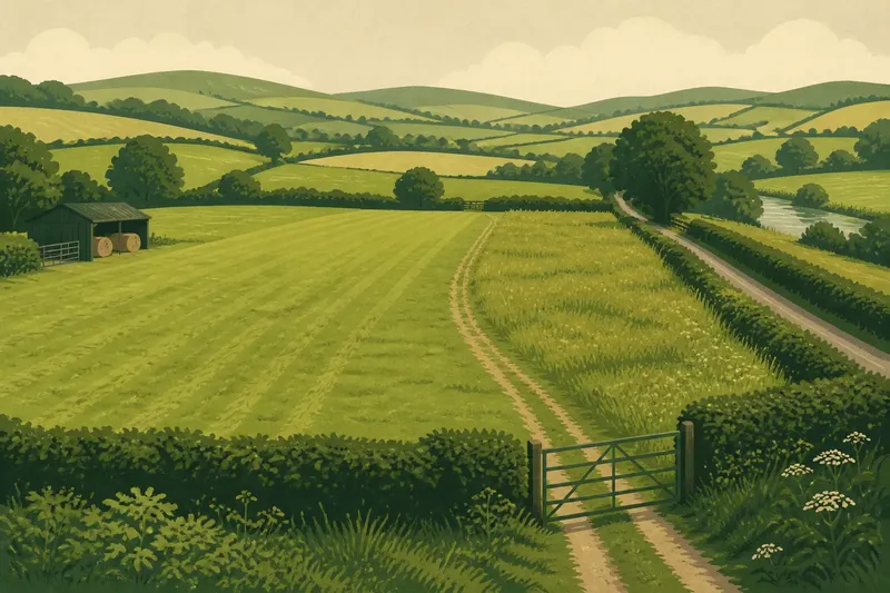
The common mistake with a green patch is to call it a meadow simply because it is open and grassy; that label can hide whether the ground is grazed, cut, resting, or serving another purpose. To read a green patch in the countryside, treat “meadow” as a possibility, not a conclusion: color and openness offer clues, but land use emerges from several details together.
Start with the visible clues
Grass cover is a broad description, not a record of what happens on the land. A short, even surface may be closely managed, while taller growth might indicate seasonal rest, a rough margin, or a place that is not currently in use. Neither appearance, on its own, tells you who manages the ground or why.
Look for changes within the patch. A sharp boundary between closely cropped grass and taller vegetation can suggest different management zones; a track worn through the surface can indicate regular access. A cluster of plants unlike those around it may mark a wet hollow, a shaded edge, or soil that is disturbed more often.
These clues are most useful when considered together. A smooth surface with parallel cut lines, an open gateway, and a nearby hay shed points toward a different pattern of use from a rough patch beside a ditch with no visible vehicle access. Even then, describe what you can observe separately from what you infer.
Meadow, pasture, or fallow?
A meadow is commonly understood as grassland managed chiefly for a hay crop, while pasture is grassland used for grazing. In everyday speech, people may use the terms loosely, and land management can change across a season. The distinction is useful as a starting point, not a claim that every field fits neatly into one category.
Grazing may leave cropped patches, animal paths, or signs of livestock, but those clues can be subtle or absent when animals are elsewhere. A meadow kept for hay may grow taller before cutting, then look unusually bare after mowing. A field with no obvious current activity might be resting, recently harvested, awaiting a change in use, or simply not being managed in a way visible from a path.
“Fallow” also needs care. It often refers to land left uncropped for a period, particularly in an arable rotation, rather than serving as a universal label for any empty-looking grass field. If you cannot see what was planted before or what is planned next, “currently uncropped” is a more defensible description than a confident claim about fallow status.
Three reading approaches
There are three useful ways to interpret a green patch: read its surface, read its setting, or seek context from people and records. Each answers a different question. The first is best for careful observation on a walk, the second helps explain how the patch relates to surrounding land, and the third is the strongest route when its history or purpose matters.
Surface reading
Surface reading starts with what is visible: grass height, plant variety, mowing lines, bare soil, wheel marks, gates, and signs of grazing. It suits walkers, photographers, and anyone who wants to describe a landscape without making claims that the view cannot support. Make a note of the season, since a recently cut hay field and a closely grazed pasture can look more alike than they do at other times.
This approach is quick, but it is easy to overread a single clue. Short grass does not automatically mean grazing; machinery can produce a similar look. A fresh track may be used for fieldwork, maintenance, or access to another feature, so its direction and connection to gates or buildings matter.
Setting reading
Setting reading asks how the patch connects to nearby features. A green area bordered by a hedge, with a gateway leading toward a farm track, belongs to a different visible pattern from a strip between a stream and a road. Its position can suggest practical roles such as access, drainage, or separation between fields, but it cannot prove one.
This approach suits readers interested in how rural features fit together. Check whether the ground slopes, where water might collect, and whether the patch narrows toward a bridge, farmyard, or lane. Notice what is immediately beside it rather than assuming that every green opening is a distinct field with one purpose.
Context seeking
When the land’s past or present use matters, ask someone responsible for the property or consult an appropriate local record, such as a map that documents field boundaries or land cover. This approach suits a person making a detailed landscape account, identifying a place for conservation interest, or trying to understand a specific management decision. A map can clarify boundaries and names, but it may not show current seasonal use.
Ask a narrow question: “Is this field cut for hay, grazed, or managed in another way?” That is more useful than asking whether the patch is “really a meadow,” since the answer may depend on local usage or a changing management plan. If you cannot verify the answer, keep the uncertainty visible in your description.
Choose a method?
How can I tell if a field is a meadow?
Look for a combination of taller grass before cutting, varied plants, and signs of a hay harvest, such as cut lines or a cleared surface afterward. These clues can support a meadow interpretation, but they do not settle the land’s use without context.
Does short grass mean the land is pasture?
No. Grazing can keep grass short, but mowing and other forms of maintenance can create a similar surface. Look for additional evidence, such as animal paths or an open gateway, and avoid treating one sign as decisive.
What does an empty green field mean?
It may be resting, between crops, cut recently, or simply quiet at the moment you pass. Without visible evidence of what came before or what is planned next, describe it as open grassland rather than assigning a firm purpose.
Which approach should I use?
Use surface reading for a cautious on-the-spot description, setting reading to understand the patch’s relation to nearby features, and context seeking when its history or management has consequences. If the question is only what the land looks like today, start with the first two and state what remains uncertain.
A worked reading
Say you come across a broad green patch beside a farm lane. One side is neatly cropped, the far edge has taller grass, and a gateway opens onto a track; there are no animals in view. Surface reading suggests that the ground is managed, but the mixed height does not establish whether it is pasture, a recently cut meadow, or separate management zones.
Next, setting reading shows that the gateway links the patch to working farm access, while the rougher edge follows a shallow ditch. That makes both access and a wetter margin plausible parts of the scene, not proven explanations. If the distinction matters, you can ask the land manager or check suitable local information; otherwise, a careful description might be “a managed grass field with a rough ditch edge and farm access.”
The point is not to avoid interpretation, but to match its confidence to the evidence. A useful field note can record the visible facts first—cropped grass, taller margin, open gate—and then offer a qualified reading. That keeps observation valuable even if later information changes your understanding.
Use labels with care
Labels shape what readers expect. “Meadow” may suggest flowering grassland or haymaking; “pasture” suggests grazing; “green space” says little about agricultural use. A broad label can be appropriate when details are unclear, while a more specific one needs enough evidence to explain why you chose it.
There is no need to turn a walk into an investigation. For a casual description, name the visible features and avoid claiming a history you cannot confirm. If the question concerns access, land ownership, conservation status, or a management decision, appearance is not enough; check the relevant local information or ask a qualified person who knows the site.
When you next see a green patch, begin with its edges, surface, and connections rather than its color. The phrase “managed grassland” can be a useful first description, and a more specific label can follow when the clues—or a reliable source—support it.