The Millpond and the Working Waterway
Millpond and working waterway clues help you read rural ponds carefully, distinguish mill infrastructure from natural water, and trace how a channel served the landscape.
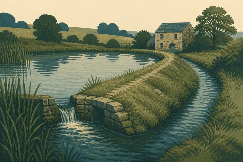
The common mistake when reading a millpond is to treat any pond beside a stream as proof of a mill; the cost is a tidy story that may not fit the ground. A millpond and working waterway are best understood through their relationships: where water enters, how it could be held or diverted, and what lies downstream. Those clues can reveal a working landscape without turning every still pool into industrial evidence.
Start with the water route
Look at the whole stretch of stream before focusing on the pond. A millpond often sits beside, rather than directly across, a natural channel, with a dam or bank holding water and a separate leat carrying it toward a mill site. A leat is a human-made channel that diverts water for a particular use.
Trace the route visually from upstream to downstream. Notice changes in channel width, straightened sections, raised banks, and places where water could rejoin the stream. A single feature may be ambiguous; a sequence that forms a plausible route is more informative.
Keep to public paths and observe from a safe distance. Banks can be soft, and old channels may be hidden by vegetation.
When the pond has no obvious outlet
A pond with no visible exit does not automatically rule out a working origin. Reeds, silt, fallen branches, or later alterations can obscure a narrow outlet, while a channel may leave at a level that is hard to see from the path. Conversely, a pond that drains through a natural low point may have formed without a mill.
Look for a low bank or a notch at one edge, then check whether a shallow linear hollow continues beyond it. The hollow might be a former leat, a field drain, or simply a damp depression, so avoid naming it from shape alone. Its direction matters: does it connect the pond to a possible working site or back to the stream?
On a map, compare the pond and stream with contours and nearby tracks. A route that follows a steady, gentle fall may be compatible with a diverted channel, though maps can omit small or filled-in features.
When the dam looks natural
A low, grassy bank can resemble a natural ridge, especially after years of weathering. Check whether it crosses a valley in a way that could hold water, and whether the pond occupies the ground immediately behind it. A bank aligned across a stream is more suggestive of deliberate control than a rounded pond in a hollow, but neither shape alone settles the question.
Look for associated features rather than digging or climbing the bank. A spillway is a route that carries excess water around or over a dam; a worn notch, a stone-lined passage, or a lower channel may mark its position. Stonework can also belong to a bridge, culvert, or later drainage system, so consider how each feature connects to the watercourse.
If the bank’s purpose remains unclear, record it as a possible water-control feature rather than calling it a mill dam.
When a channel seems too straight
A straight channel may look unmistakably artificial, but straightness alone does not identify its age or purpose. Farmers have reshaped watercourses for drainage, boundaries, irrigation, and flood management; a mill leat is only one possibility. A modern ditch can also follow the line of an older channel.
Check whether the channel appears to branch from the stream upstream and return farther down. Then look for a setting where controlled flow would make sense: a former building platform, a surviving mill building, or a place where the channel passes close to a settlement or working yard. These are clues, not a complete proof, and a mill structure may have disappeared.
Say you see a narrow channel leaving a stream, bending behind a low bank, and returning near an old stone building. If the map also shows a gentle fall along the channel, you could describe a plausible diverted water route and note that its original purpose is uncertain. That account fits the visible evidence without assigning the building a use the landscape cannot confirm.
When the mill site has vanished
Waterworks often outlast the building they served. A pond may remain after a mill has been demolished, while a leat survives as a damp strip, a line of rushes, or a shallow trench in pasture. The absence of a recognizable wheel, turbine, or mill building is therefore not enough to dismiss a working-waterway interpretation.
Search the surroundings for a cluster of related traces: a widened section of stream, a platform beside the channel, a short tailrace leading away, or a road approach to the former site. A tailrace is the channel that carries used water away from a mill. If several elements align, the landscape supports a stronger interpretation than any isolated hollow.
Use cautious wording in notes or conversation: “possible millpond” or “former water channel” preserves the distinction between observation and inference.
Reading the working waterway?
Does every millpond have a visible mill?
No. Buildings can be removed, rebuilt, or absorbed into later farms, while the pond and channels remain. A lack of a surviving mill means the site needs more careful interpretation, not that the pond was necessarily natural.
Can a pond prove that a mill operated nearby?
A pond by itself cannot establish that history. A diversion channel, a plausible downstream return, and a related building site together make a more coherent case, though the features may still have served another purpose.
What is the difference between a leat and a drain?
A leat diverts water toward a use, such as powering machinery, while a drain carries unwanted water away from land. Their shapes can overlap, so direction, connection points, and nearby features help distinguish them.
Why might a former channel be dry?
Its flow may have been redirected, blocked, or made unnecessary by changes to the site. A dry hollow can still mark an old route, but it should be read alongside the surrounding banks and stream rather than as evidence on its own.
What maps can and cannot show
Historic and current maps can help compare a pond’s outline, stream course, nearby buildings, and place-names. Look for a channel that appears on one map but not another, or for a building that changes footprint while the water features persist. A map records selected details at a particular time; omissions do not establish that a feature never existed.
Place-names containing words such as “mill” can point to a useful question, but names can outlive the activity that gave rise to them or refer to a different site. Treat them as leads to check against the terrain, not as a verdict.
Where the interpretation depends on a map’s date or a place-name’s history, local archives or a knowledgeable local history group may help clarify the evidence.
Describe what you can see
A clear field description separates visible features from explanation. Write down the pond’s position, the direction of any channel, the shape of banks, and where water appears to enter or leave. Then state the interpretation with a degree of caution that matches the evidence.
- Record whether the pond touches the stream or sits beside it.
- Note any channel that branches away or rejoins downstream.
- Describe banks, notches, and stonework without assigning them a purpose too soon.
- Check whether nearby buildings, tracks, or platforms relate spatially to the water.
- Compare the visible arrangement with a map, while noting features that maps may omit.
This approach makes the millpond and working waterway legible as parts of rural life: evidence of water being held, moved, or managed, but not a label to apply to every pond. The most useful final observation may be a small one: whether the channel’s fall and return route make the proposed use physically plausible.